


Can you believe that New Hampshire was once home to active volcanoes? The Lakes Region of New Hampshire, particularly the area surrounding Lake Winnipesaukee, is a landscape defined by its geological history. This history, spanning hundreds of millions of years, has been shaped by ancient seas, volcanic eruptions, and the powerful forces of glaciation. These processes have left behind a region rich in unique features that tell the story of our region.
Lake Winnipesaukee, the largest lake in New Hampshire, is the most dominant feature of our region. The lake's formation can be traced back to the last ice age, a period that began around 2.6 million years ago and lasted until approximately 12,000 years ago. During this time, much of North America, including what is now New Hampshire, was covered by the Laurentide Ice Sheet. This massive sheet of ice, at its peak, was nearly a mile thick and extended across most of Canada and the northern United States. As the glacier moved, it scoured the landscape, carving out valleys, grinding down mountains, and depositing large amounts of sediment in its wake.
As the last glacial period came to an end, the Laurentide Ice Sheet began to retreat. During this lengthy process, the glacier experienced alternating phases of melting and deposition, scattering sand, clay, gravel and giant boulders. These materials, known as glacial till, were left unevenly distributed across the landscape. In some areas, the glacier gouged out deep depressions, while in others, it deposited large mounds of sediment. As the ice continued to melt, these depressions filled with water, giving rise to the many lakes and ponds that now dot the region, with Lake Winnipesaukee being the most significant.
The formation of Lake Winnipesaukee is closely tied to the region's bedrock geology. The lake lies within a lowland area that was formed through the erosion of weaker rocks by streams and the forces of glaciation. The harder, more resistant rocks were left standing as ridges and hills, some of which now form the peninsulas and islands of the lake.
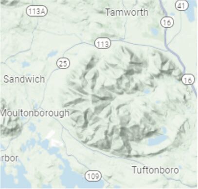
Beyond Lake Winnipesaukee, the surrounding landscape is equally fascinating. One of the most striking geological features in the region is the Ossipee Mountain Range, located to the northeast of the lake. This range is distinguished by its nearly perfect circular shape, which can be easily seen on topographical maps.
The formation of the Ossipee Mountains is the result of ancient volcanic activity, dating back approximately 90 million years. The circular shape of the range is known as a ring dike, a rare geological formation that occurs when magma from a volcano intrudes into the surrounding rock in a circular pattern. The original volcano that formed the Ossipee ring dike is believed to have been about 10,000 feet tall, a towering presence that dominated the landscape.
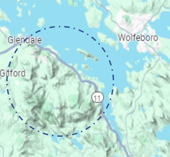
The Ossipee Mountains are not the only example of a ring dike in the region. To the south of Lake Winnipesaukee lies the Belknap Mountain Range, another remnant of ancient volcanic activity. The Belknap Mountains, like the Ossipee Mountains, were formed by a series of volcanic eruptions that took place over millions of years. The outer ring dike of the Belknap Mountains extends for about six miles and includes Rattlesnake Island, which, although it appears as a solitary island in the middle of the lake, is actually part of the larger volcanic structure.
The geology of the Lakes Region is a testament to the powerful natural forces that have shaped this landscape over hundreds of millions of years. From the ancient seas that once covered the area to the volcanic eruptions that formed the Ossipee and Belknap Mountains, to the glacial ice that carved out Lake Winnipesaukee, each feature of the region tells a story. The peninsulas and islands that now dot Lake Winnipesaukee are not just picturesque landscapes; they are the remnants of a complex geological history.
Today, as we explore the region, whether by boat on Lake Winnipesaukee or by hiking the trails of the Ossipee or Belknap Mountains, we are walking through a landscape that has been millions of years in the making. The next time you find yourself gazing at the mountains or the waters of Lake Winnipesaukee, take a moment to consider the ancient processes that brought them to life.
•••
Bree Rossiter is the conservation program manager for the Lake Winnipesaukee Association. She manages the water quality monitoring program, cyanobacteria monitoring initiatives, the Winni Blue/LakeSmart program, and assists with watershed management planning efforts. Bree can be reached at brossiter@winnipesaukee.org. The Lake Winnipesaukee Association is a nonprofit dedicated to protecting the water quality and natural resources of the lake and its watershed. To learn more, visit winnipesaukee.org.


(0) comments
Welcome to the discussion.
Log In
Keep it Clean. Please avoid obscene, vulgar, lewd, racist or sexually-oriented language.
PLEASE TURN OFF YOUR CAPS LOCK.
Don't Threaten. Threats of harming another person will not be tolerated.
Be Truthful. Don't knowingly lie about anyone or anything.
Be Nice. No racism, sexism or any sort of -ism that is degrading to another person.
Be Proactive. Use the 'Report' link on each comment to let us know of abusive posts.
Share with Us. We'd love to hear eyewitness accounts, the history behind an article.