


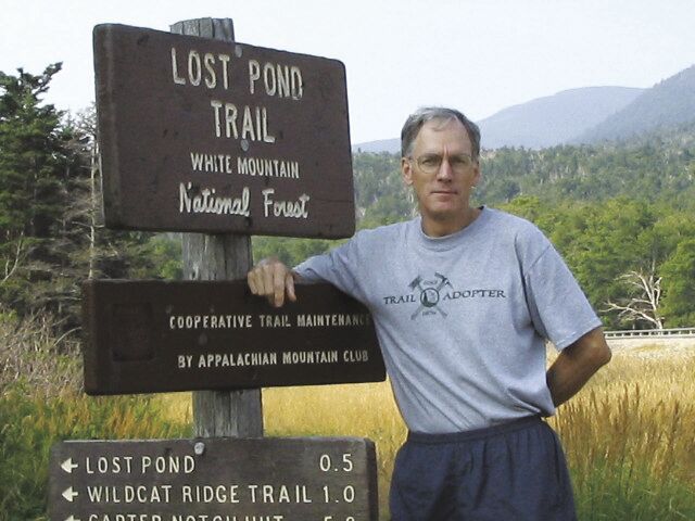
Larry Garland has been making hiking maps for the Appalachian Mountain Club since 1996. His story is worth highlighting.
He didn’t start out thinking he would be a cartographer. He got a bachelor’s degree in business administration and a masters in computer information systems. Later in his career however, that would help in managing map data.
In the 1980s and early 90s, he worked in an office on the 31st floor of a building in Boston. From his window he could see Mount Monadnock in southern New Hampshire, and the lure of the wild was powerful. His midlife crisis occurred when a company merger would have required he move to New Jersey.
He decided to get off the corporate treadmill, and take a year off to travel and climb. One year turned to two, then three. While on his travels, he climbed some of the continental high points, including Mount Elbrus in Russia, Mount Kilimanjaro in Kenya, Mount Aconcagua in Argentina, and Denali in Alaska. “I was in my 40s,” he said “and was tied onto a rope with 20-somethings, so I had to push it.”
In New England he red-lined all the trails in the AMC White Mountain Guide and did the New Hampshire 3,000 footers in the winter.
“I was still trying to figure out my next career move when I saw an article in the monthly AMC magazine. The AMC was doing a northern forest land inventory. This was a time when the paper companies were selling off large tracts of land.” He asked the AMC for a job. There was no full-time work, but the AMC had received a grant, and hired him for one summer.
During that part-time stint, Garland gained experience in processing satellite images and using geographic information software. At that time, the AMC hiking maps were based on the work of Louis F. Cutter, who made AMC maps from 1885 to his death in 1945. These were updated by hand, an expensive process that was not totally accurate. Garland suggested to the AMC that they could make better hiking maps using geographic information software.
The AMC gave Garland the go ahead. He had to figure out how to make a map digitally. “I had never made a map before,” he said. His first assignment was to make the maps for the 1998 AMC White Mountain Guide. He began the work in 1996.
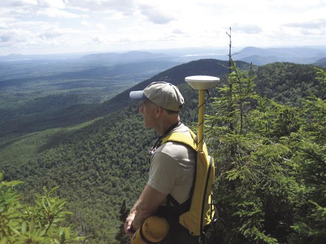
“There was little digital data back then,” he said. “I had to figure out how to cobble together data.” He used an “industrial GPS” that fit in a backpack, and walked the trails to collect data via satellite. Even the roads were inaccurate on the old maps and he had to drive many of them to collect data. That was only part of the job. The rest occurred in his office, where the data was downloaded, assimilated and rendered in other software.
During this time, he thought: “Do I have this job because I hike, or do I hike because I have this job?”
From the early success of Garland’s maps, he has become a trail map maker for New England, including other hiking clubs and organizations.
The AMC publishes new editions for each of its guidebooks approximately every five years. “There is a surprising amount of work updating new guides, and collaborating with the editors,” he said. When the 1998 AMC White Mountain Guide came out, that was the first year an AMC Southern New Hampshire Trail Guide came out separately. Since then, he has also made maps for the AMC Maine Mountain Guide, Acadia National Park, the AMC Catskill Trail Guide and AMC Massachusetts Trail Guide.
He also has produced large format interpretative maps for Northern New Hampshire, The 100 Mile Wilderness, the Mahoosucs, the Androscoggin River, the Saco River, the Deerfield River, Rhode Island, the New England National Scenic Trail, and the Bay Circuit Trail — a 200 mile trail in eastern Massachusetts.
He made maps for the Shelburne Trails Club, the Waterville Valley Athletic and Improvement Association, Chatham Trails Association, Cohos Trail, the Maine Highlands, the Kl Jo-Mary Forest, Lakes Region Conservation Trust, Three Rivers Land Trust (in southern York County, Maine) and the Loon Echo Land Trust in Bridgeton, Maine. He has also made mountain bike and cross country ski maps.
Living in Jackson and presently continuing his work at home instead of his office at AMC Pinkham Notch, he also works with the AMC conservation department, doing assessment and feasibility studies of new trails all over New England. For example, a possible connecting trail between the Cohos Trail in northern New Hampshire and southern New Hampshire trails. This would include working with land trusts, state agencies and private landowners.
For those of us who love maps, and travel in the wilds of New England, we can thank Larry Garland for his work, as can generations to come.
•••
Ed Parsons of Tamworth has written a hiking column for various newspapers in the Mount Washington Valley, and for the Conway Daily Sun since the early 1990s. Since moving to Tamworth 7 years ago, he ranges frequently into the Lakes Region for hikes as well.


(0) comments
Welcome to the discussion.
Log In
Keep it Clean. Please avoid obscene, vulgar, lewd, racist or sexually-oriented language.
PLEASE TURN OFF YOUR CAPS LOCK.
Don't Threaten. Threats of harming another person will not be tolerated.
Be Truthful. Don't knowingly lie about anyone or anything.
Be Nice. No racism, sexism or any sort of -ism that is degrading to another person.
Be Proactive. Use the 'Report' link on each comment to let us know of abusive posts.
Share with Us. We'd love to hear eyewitness accounts, the history behind an article.