


Fran and I were on another hike to an untrailed peak, Shoal Pond South Peak, also known as Twin Top Mountain (2,891 ft.). The mountain lies alongside its sister summit, Shoal Pond Peak (3,051 ft.). Both mountains are nestled in a remote area of the Pemigewasset Wilderness and are rarely climbed. Two years ago Fran and I climbed to the summit of Shoal Pond North (Paths Less Travelled, Walking Into Color, pp. 150-154). This time we would take the Eastside Trail to the Thoreau Falls Trail and bushwhack to the summit from the western side of the mountain.
When we arrived at Lincoln Woods parking lot off the Kancamagus Highway (NH 112) at 6:30 a.m. the area was already half full of vehicles. This is one of the most frequented destinations for tourists and trekkers wanting to hike into this spectacular federally designated Wilderness Area. On many summer days the parking lot is full by 9:00 a.m., with cars parked on the shoulder of Route 112. Fran and I didn’t plan to join the hordes of hikers heading into the Pemi Wilderness by way of the Lincoln Woods Trail. We would take much less frequented trails before we began our bushwhack to the summit of Shoal Pond South Peak. On our ramble along the Eastside Trail and the Thoreau Falls Trail we encountered only 3 other hikers the whole day.
The Pemigewasset Wilderness is a vast wilderness of 45,000 acres, federally designated as Wilderness Area. It was created in 1984 under the authority of the 1964 Wildness Act, and is one of six federally designated wilderness areas in the White Mountain National Forest. The others being Presidential/ Dry River Wilderness, Great Gulf Wilderness, Sandwich Range Wilderness, Wild River Wilderness and the Caribou/Speckled Mountain Wilderness.
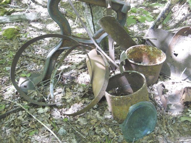
Located in the expanse of unbroken forest are several 4,000 foot peaks as well as lesser peaks, numerous streams and rivers, including the East Branch of the Pemigewasset River and many miles of hiking Trails. Prior to the logging boom of the late nineteenth century, the area drained by the East Branch of the Pemigewasset River, held an unbroken virgin forest. By the early 1900s the wilderness was quickly disappearing with the advent of logging operations led by J.E. Henry and his sons. They built an extensive system of rail lines and many are used as trails today. Evidence of logging camps can be observed by the clearings in the forest. Relics of camp life, such as bed frames, cook stoves, saws, pots and pans are hidden in these clearings . Two excellent books recount the history of logging in this area: Logging Railroads of the White Mountains by C. Francis Belcher (out of print) or Bill Gove’s J.E. Henry’s Logging Railroads.
We began our hike on the Eastside Trail (Forest Rd. 87) by sauntering three easy miles, until we reached the Franconia Brook Tent Sites. This campsite is snuggled along the river and is ideal for a family backpack-tenting adventure. It’s an easy jaunt along the picturesque river to the campground. The hike offers many places for swimming in the pristine waters of the East Branch. This was confirmed when we heard the delightful squeals of children along the river bank while we made our way along the trail.
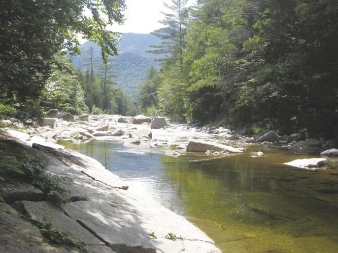
After leaving the campsites we continued on the Eastside Trail. We were tempted to take a dip in the water, but had to move along as it was several miles further to the start of the bushwhack. When we reached the junction with the Cedar Brook Trail the path transitioned to the Wilderness Trail. Several years ago the Wilderness Trail, which hugs the western side and northern side of the North Branch, crossed the river at this point on a suspension bridge. It was removed in 2009. (Shortly after its removal, I expected to cross the river via the bridge and found it had vanished, just the abutments remained. Not to be deterred in my planned route, Reuben found a crossing that we could safely wade across. However, this crossing is not recommended, especially during periods of high water).
Trekking another mile on the Wilderness Trail we came to the Junction with the Thoreau Falls Trail, where we needed to cross the river. The dilapidated railroad bridge that at one time provided a safe crossing of the river was removed by the U.S. Forest Service two years ago under the authority of the 1964 Wilderness Act. "A wilderness, in contrast with those areas where man and his own works dominate the landscape, is hereby recognized as an area where the earth and its community of life are untrammeled by man, where man himself is a visitor who does not remain." - Howard Zahniser, chief architect of the federal legislation.
The proposed removal sparked a tumultuous controversy. The U.S. Forest Service took public comment, considering the pros and cons of the issue. On the one hand, avid trekkers, who often hiked or skied this trail, favored replacing the bridge, while defenders of the wilderness, like myself, advocated tearing down the structure, retuning the forest to its natural beauty. After two years of public input, the Forest Service decided to remove the crumbing bridge. The area around the bridge has now been returned to its natural state and the river must be forded in order to reach the Thoreau Falls Trail.
Fran and I brought our crocs, slipped them on and crossed the river safely. The cool, clear water of this unspoiled river refreshed our hot tired feet, and provided a relaxing respite before continuing our trek. The Thoreau Falls Trail followed one of Henry’s logging rail beds running beside the North Fork of the East Branch. Along our route we found the remains of logging camp 22, one of many logging camps of J.E. Henry’s extensive system camps throughout the Pemigewasset Wilderness . If you have an interest in finding these camps and exploring their vestiges, maps can be found in both the Gove and Belcher books. Remember that any relics from the camps or railroad must be left where they are. They are protected by the Antiquities Act of 1906.
Within a mile after wading through the North Branch of the Pemigewasset River we came to the start of our bushwhack to Shoal Pond South Peak. For .7 miles we trudged up the mountain, pushing through brambles, hip-high ferns, tightly knitted hobblebush and spruce thickets. Jumping from a log, my face ran into a broken branch, just missing my eye. With my cheek bleeding, my legs filled with scratches and my arms cut by sharp brambles I made it to the summit. Fran and I gave a celebratory cheer, signed the register and headed back down the mountain. We met our goal and now we faced a nine mile slog back to Lincoln Woods.
When I returned home, bruised and battered, with my face looking like a had been in a barroom brawl, my legs and arms full of scratches as if I had been attached by a cat, my wife Nancy asked me, “Why do you put yourself through that agony, climbing a remote mountain.” My reply, “Because it’s there.”
•••
For questions and comments, contact Gordon at forestps@metrocast.net.


(0) comments
Welcome to the discussion.
Log In
Keep it Clean. Please avoid obscene, vulgar, lewd, racist or sexually-oriented language.
PLEASE TURN OFF YOUR CAPS LOCK.
Don't Threaten. Threats of harming another person will not be tolerated.
Be Truthful. Don't knowingly lie about anyone or anything.
Be Nice. No racism, sexism or any sort of -ism that is degrading to another person.
Be Proactive. Use the 'Report' link on each comment to let us know of abusive posts.
Share with Us. We'd love to hear eyewitness accounts, the history behind an article.