


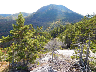
View from the summit of Hedgehog Mountain, with Mt. Passaconaway in background.
By Gordon DuBois
A few days ago I awoke to find the skies overcast and a steady drizzle predicted to fall all morning. I was planning to hike King Ravine and summit JQ Adams, an "unofficial" 4,000 footer on the side of Mount Adams. The weather forecast did not sound promising, therefore I needed to change my plans. I studied the AMC Guide and map, looking for an interesting hike I could do with Reuben and not deal with inclement weather I would most likely find in the Presidential Range.
I remembered years ago I had hiked a small knob off the Kancamagus Highway called Hedgehog Mountain (2,532 feet). This mountain is not be confused with the Hedgehog Mountain in Wonalancet. Hedgehog is a strange name for a mountain since hedgehogs are not native to New Hampshire or even North America. They can be found in Europe, Asia and Africa, but not here. So how did this mountain get its name? The mountain summit is accessed via the UNH trail, so named because at one time the University of New Hampshire Forestry Camp was located in the vicinity of the mountain. Perhaps some inventive forestry student thought the mountain looked like this ancient (over 15 million years old) spiny animal that's related to the porcupine.
After waiting a couple hours for the weather to clear, I headed up I-93 to the "Kanc." Lincoln was abuzz with leaf peepers, out and about, walking the streets, wandering in and out of the many shops and restaurants lining Main Street. My drive took me over Kancamagus Pass, past turn offs and parking lots filled with tourists admiring the mountain vistas that were beginning the multi-colored show of autumn. The skies had cleared and a bright sun was warming the air. Reuben and I arrived at the trailhead parking lot located opposite that White Mountain National Forest, Passaconaway Campground. When we pulled into the lot we strangely found only two other cars. I assumed that with the many tourists who flock to this area in autumn the lot would be filled with autos and the trail busy with hikers.
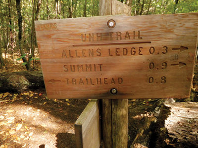
I began my hike with Reuben running ahead of me as usual. He was happy to be hiking again, after a long lay-off. We followed the Downs Brook Trail for a short distance and then began our trek along an old railroad bed. We soon came to the junction with the UNH Trail. This is where confusion set in. One trail sign read "UNH Ski Trail" the other "UNH Trail". I was curious to find out where the UNH Ski Trail would take me, so I decided to begin my hike on this trail, thinking it might take me to Hedgehog; wrong idea! The ski trail led me into a large wetland. After hiking for some time I realized the ski trail was taking me away from the mountain, so I turned around and returned to the trail head, where I began. This was an interesting exploratory tramp, but not one I had planned.
After returning to the UNH trail I began an easy climb, following yellow blazes to the beginning of the trail loop. Here I had to make a decision. The trail begins a circuitous route over and around the mountain. By taking the loop to the left I would head in a clockwise direction, gaining elevation to the ledges. I chose to go right heading in a counter clockwise direction. This path would take me to Allen's Ledges and the summit of Hedgehog. The trail began to climb steeply over rock and roots that proved to be slippery after the rainfall. Reuben scampered along while I carefully plodded up the trail, trying to avoid the many wet roots and rocks lining the trail. As the trail gained elevation and continued its way up the mountain I began to notice the yellow blazes on trees were barely visible or even nonexistent. The tread way was well worn, so I knew I was on the trail. I checked my map to ensure that I was still on the trail. I then realized Hedgehog Mountain lies within the Sandwich Range Wilderness. Since this is a federally-designated wilderness area, any man made features including trail signs and blazes are kept at a minimum.
When I reached the summit I found the skies had cleared. The views were astounding. Mount Passaconaway, at 4,048 feet, dominated the sky line to the south. It loomed over me like a giant, watching as I rested and ate my lunch. I shared my sandwich with Reuben and a visiting chipmunk, who rested at my feet waiting for a snack. He scurried back and forth with my discarded peanuts, disappearing and then emerging from the woods looking for more. I wondered if he was storing his food cache for the winter. It's only 70 days before the Winter Solstice arrives. I was reluctant to leave this rock summit, with its magnificent views, but I realized I needed to move on if I was going to make it home for supper.
I continued my trek, by heading down the mountain, continuing in a counter-clockwise direction toward the east ledges. The trail dropped steeply off the rock face of the summit. The blazes were faint and I needed to be cautious to stay on the trail. There were several side paths that may have led to other sections of the mountain. I wondered if any of these were part of an abandoned trail that climbed Mount Passaconaway, up the north side. The trail descended into the forest below the summit and then began to climb moderately via switchbacks to the east facing cliffs. Again, spectacular views to the north and east awaited me. The trail followed the edge of the cliffs. There were no cairns and blazes were very faint on the rocks, so I had to be cautious along this section of the trail. The trail then dipped into the woods, continuing its circuitous route back to the loop junction, where Reuben and I then turned right and made our way back to the parking lot.
This was a great half-day hike of 4.8 miles. It presented a stimulating climb through rich spruce forests and along rock ledges that offer outstanding views of the Sandwich and Presidential Ranges. It is a moderately difficult hike and can be combined with a climb to the summit of Potash Mountain (1,450 feet), for a full day of hiking. Potash lies adjacent to Hedgehog and is climbed via the Downs Brook Trail to the Potash Trail. With the magnificent colors of our northern forest on full display over the next two weeks it would make an ideal hike for the entire family.
trail sign on UNH trail


(0) comments
Welcome to the discussion.
Log In
Keep it Clean. Please avoid obscene, vulgar, lewd, racist or sexually-oriented language.
PLEASE TURN OFF YOUR CAPS LOCK.
Don't Threaten. Threats of harming another person will not be tolerated.
Be Truthful. Don't knowingly lie about anyone or anything.
Be Nice. No racism, sexism or any sort of -ism that is degrading to another person.
Be Proactive. Use the 'Report' link on each comment to let us know of abusive posts.
Share with Us. We'd love to hear eyewitness accounts, the history behind an article.