


LACONIA — As a young boy, Michael Bruno once had a brown bag lunch with his father in Bow near a state roadside marker memorializing a visit by President Andrew Jackson.
“Just north of this point, on the boundary between Bow and Concord, a large cavalcade of enthusiastic citizens met President Jackson and escorted him to New Hampshire’s Capital,” states the marker at Route 3A and Interstate 89. “His official reception by the State Government on the following day, June 29, 1833, marked the conclusion of a triumphal New England tour.”
Bruno’s young mind conjured up an image of a presidential party riding horse-pulled wagons where cars now speed by at 70 mph.
He later found another marker, this one in Franklin. It painted a picture in his young mind of Native Americans giving thanks for rivers teeming with fish.
The Indian Mortar Lot marker at U.S. Route 3 and Dearborn Street contains a glacial boulder where a portion has been rounded into a mortar bowl apparently used by Indians grinding corn. Also carved into a boulder is a likeness of a shad, which swam up the Winnipesaukee River in great numbers before dams ended fish runs.
As Bruno grew older and became an avid motorcyclist, he would stop and read each historical marker he would pass.
One noted the history of a once-thriving train station at New Hampshire Route 132 and Winter Street in Ashland, where one could hop aboard the Boston, Concord and Montreal Railroad.
Nearby, at Route 132 and Route 3, a marker notes the home of Dr. George Hoyt Whipple, who won the Nobel Prize for his work on liver therapy.
In Rumney, on Stinson Lake Road, 2 miles north of New Hampshire Route 25, is a marker at Loveland Bridge, where industrial companies drew water power from Stinson Brook. One made crutches sent around the world.
Bruno served in the U.S. Army for more than 23 years and returned to New Hampshire in 2009, where he is an instructor at White Mountains Regional High School in Whitefield.
He decided to write a book documenting each of the 255 New Hampshire historical markers.
After more than two years of work, he has produced “Cruising New Hampshire History,” which pinpoints each marker by road location and GPS coordinates. He tells the story of each sign.
The markers fuel the imagination about a different, and in many ways, more difficult time.
In many old pastures bound by rock walls, one can only imagine the difficulty of clearing land, pulling stumps and moving boulders without the aid of modern machines.
“The requirement on the first wilderness tracks was you had to clear five acres and maintain the road,” he said. “They were cutting trees by hand and using oxen to pull out trunks. It was laborious work."
Battles in the French and Indian War were occurring.
“We were the wilderness for the Massachusetts Bay Company. Fort No. 4 in Charlestown was the farthest fort north on the Connecticut River. The other side was wilderness.”
A sign at New Hampshire Route 12 and Main Street in Charlestown marks the site of the old fort.
“In 1744, the settlers at No. 4 (now Charlestown) built a great log fort enclosing many of the town’s dwellings,” the sign states. “The fort, northernmost in the Connecticut Valley, was besieged in 1747 by a large force of French and Indians, who were beaten off by the 31-man garrison in a 3-day battle. The fort was never again attacked.”
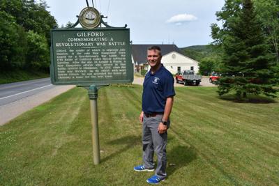
In addition to affording the traveler a chance to marvel at bygone eras, some of the signs explain the history behind modern names, such as the town of Gilford.
On Route 11A, near the fire station in Gilford Village, a marker notes the town takes its name from the Revolutionary War battle of Guilford Court House, in which American troops forced a retreat by the forces of British Lt. Gen. Charles Cornwallis.
“After the war, Lt. Lemuel B. Mason, a New Hampshire officer who served in that battle, retired to Gilmanton,” the sign states. “In 1812, when the town was divided, as its oldest and most famous citizen, he was accorded the honor of choosing a name for the new town."
A clerical error later dropped the “u” from the town name, giving it its present spelling, Gilford.


(0) comments
Welcome to the discussion.
Log In
Keep it Clean. Please avoid obscene, vulgar, lewd, racist or sexually-oriented language.
PLEASE TURN OFF YOUR CAPS LOCK.
Don't Threaten. Threats of harming another person will not be tolerated.
Be Truthful. Don't knowingly lie about anyone or anything.
Be Nice. No racism, sexism or any sort of -ism that is degrading to another person.
Be Proactive. Use the 'Report' link on each comment to let us know of abusive posts.
Share with Us. We'd love to hear eyewitness accounts, the history behind an article.