


LACONIA — It’s either feast or famine, so the saying goes. And that old saying applies to the weather of late.
That certainly can be said of rainfall — with news reports of widening drought conditions in June, followed days later by urgent advisories of the possibilities of flash floods.
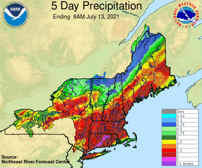
Rain has fallen every day this month except one, according to Brendon Hoch of Plymouth, a regional coordinator for the Community Collaborative Rain, Hail, and Snow Network — CoCoRaHS for short — a non-profit, community-based network of volunteers who measure and map precipitation. Hoch oversees the data recorded on Belknap, Grafton, Sullivan, and Merrimack counties.
As of Monday 6.75 inches of rain had fallen in July in Concord, which is the closest official National Weather Service weather recording station with long-term climate records, according to Michael Clair, a meteorologist at the National Weather Service office in Gray, Maine. That amount of rain is 4 1/2 times greater than what would normally fall during the first 12 days of July, he said.
Recent rainstorms, including the remnants of Tropical Storm Elsa which moved through the area Friday, have dumped more rain in the southern part of the state. Last Friday alone, 1.61 inches fell in Concord. But the Lakes Region has racked up some pretty impressive rainfall totals as well.
A data collection station in Laconia, on the eastern edge of Lake Winnisquam, has recorded 5.02 inches this month, while another in Gilford, near Ellacoya State Park, registered 4.85 inches.
Clair said the changing weather pattern has been responsible for the notable increase in rainfall.
“In June we were under a ridge of high pressure,” he said. “But it shifted. And now we’re more into more of a storm track.”
That trend appears to be continuing, with more rain predicted this week.
Possible thunderstorms are on tap for today.


(0) comments
Welcome to the discussion.
Log In
Keep it Clean. Please avoid obscene, vulgar, lewd, racist or sexually-oriented language.
PLEASE TURN OFF YOUR CAPS LOCK.
Don't Threaten. Threats of harming another person will not be tolerated.
Be Truthful. Don't knowingly lie about anyone or anything.
Be Nice. No racism, sexism or any sort of -ism that is degrading to another person.
Be Proactive. Use the 'Report' link on each comment to let us know of abusive posts.
Share with Us. We'd love to hear eyewitness accounts, the history behind an article.