


Around Lake Winnipesaukee this spring, the lake level has become hard to ignore.
Docks are partially submerged, shoreline access has become more difficult, and conversations around the lake increasingly center on the same questions: Why is the lake so high and why can’t more water simply be released faster?
The answer is more complicated than many realize.
Lake levels are managed by the New Hampshire Department of Environmental Services Dam Bureau. Managing the water level on New Hampshire’s largest lake is a constant balancing act between shoreline considerations, downstream flooding risks, recreation, navigation, hydropower operations, weather forecasts, and ecological health.
Spanning roughly 72 square miles of surface water with more than 270 miles of shoreline, Lake Winnipesaukee is not managed as an isolated waterbody. Water leaving the lake flows through Paugus Bay, the Lakeport Dam, Lake Opechee, Lake Winnisquam, Silver Lake, and ultimately into the Winnipesaukee River system, impacting communities throughout the watershed.
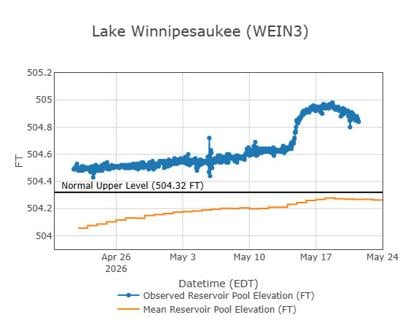
On May 21, Lake Winnipesaukee measured 504.87 feet, approximately 6.24 inches above full lake level, after peaking at 504.97 feet on May 18, roughly 7.8 inches above full. For comparison, on May 22, 2025, the lake measured 504.63 feet, despite the region having received nearly 4 inches of rain by that point last May compared to just 2.4 inches this May.
That difference highlights an important point: rainfall alone does not determine lake level. Saturated soils, groundwater inputs, snowmelt, runoff throughout the watershed, and changes in land use that increase impervious surfaces all affect how quickly water enters the lake and how long elevated water levels can persist.
A common question this time of year is why more water cannot simply be released ahead of forecasted storms. While weather forecasts play an important role in lake management decisions, lowering the lake too aggressively too early can create challenges later in the season, especially if conditions change.
There are also practical limits to how much water can safely be released downstream.
Under deeded water rights dating back to the 1800s, hydropower facilities on the Winnipesaukee River are entitled to a minimum release of 250 cubic feet per second, equal to more than 112,000 gallons per minute. On Thursday, the Dam Bureau reported an outflow of approximately 1,550 cfs moving through the system, nearly three times the lake’s long-term average outflow of approximately 550 cfs (Bizer).
To put those numbers into perspective, 1,920 cfs is enough water to fill roughly 45 swimming pools every minute. Over a 24-hour period, that flow equals approximately 1.24 billion gallons of water, enough to lower Lake Winnipesaukee by only about one inch. Even very large releases only lower the lake incrementally, especially when continued rainfall and runoff are pouring into the system at the same time. You can view the lake level and flow rate at nhdes.rtiamanzi.org.
High water also makes responsible boating especially important. Large wakes during elevated lake levels can accelerate shoreline erosion, damage docks and stir up sediment and nutrients that can negatively impact water quality.
As Memorial Day weekend begins on Lake Winnipesaukee, current conditions are an important reminder to recreate responsibly and stay aware on the water. Despite warm air temperatures, lake temperatures are still hovering around 55 degrees, cold enough to trigger shock and hypothermia within minutes if someone unexpectedly enters the water. Combined with elevated water levels, floating debris, and increased shoreline vulnerability, early season boating conditions require extra caution and responsible operation on the water to help ensure a safe and enjoyable holiday weekend.
•••
Bree Rossiter is the Associate Director of the Lake Winnipesaukee Alliance, the only nonprofit dedicated to protecting the water quality and natural resources of Lake Winnipesaukee and its watershed through science, education, advocacy, and collaborative solutions. Her work focuses on advancing long-term watershed protection initiatives and connecting science with practical solutions to help preserve the lake for future generations. To learn more, visit winnipesaukee.org.


(0) comments
Welcome to the discussion.
Log In
Keep it Clean. Please avoid obscene, vulgar, lewd, racist or sexually-oriented language.
PLEASE TURN OFF YOUR CAPS LOCK.
Don't Threaten. Threats of harming another person will not be tolerated.
Be Truthful. Don't knowingly lie about anyone or anything.
Be Nice. No racism, sexism or any sort of -ism that is degrading to another person.
Be Proactive. Use the 'Report' link on each comment to let us know of abusive posts.
Share with Us. We'd love to hear eyewitness accounts, the history behind an article.