


A long-running dispute over access to a gravel pit has led to the blockage of the Northern Rail Trail in Andover, forcing bikers and walkers to travel along Route 4 instead.
“There is currently no state-approved detour,” signs posted by the New Hampshire Department of Transportation announce at either end of the mile-long blockage. The agency is “evaluating specific legal and administrative options,” the signs add, and “the closure may remain in place for some time.”
The former Boston & Maine rail corridor was bought by the state in 1995 and has been a well-used trail for many years.
Landowner Leonard Caron placed the multi-ton Jersey barriers in front of the trail two weeks ago. He said the signs demonstrate that his argument over control of the former Boston and Maine railroad bed has merit. “Apparently, they ain’t so sure of themselves,” he said in a phone interview Tuesday.
The town of Andover says it has no jurisdiction, since rail rights-of-way are a function of federal and state rules.
“Until the state pushes back and takes the barriers away, they’re going to stay there. This isn’t a town issue,” said Christine Vigneault, the land use coordinator for Andover.
Caron said the dispute was triggered by changes to the Keniston Bridge, a historic covered bridge in town, which made it impossible for certain tall, heavy equipment to cross. Caron had used it to access his gravel pit. With that route closed, he used a portion of the rail trail instead, leading to a cease-and-desist order because heavy machinery isn’t allowed there either. That prompted him to study property documents dating back to the 1800s, he says: “I did some research on the deed and found out they had no rights to the land.”
Caron claims he and previous owners of four parcels that are landlocked with no other access routes had long-standing agreements to use the corridor when Boston & Maine still owned it.
“I used to lease that track, when the railroad owned it. They charged me $200 a year. … I was using it before the state even got involved,” he said.
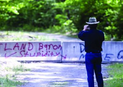
Two weeks ago, Caron placed the barriers with an excavator, blocking the trail between Bridge Road and Cilleyville Road. As part of the work near Potter Place, a former B&M station, he moved gates designed to keep ATVs off the trail — snowmobiles are allowed in winter — and pulled up a couple sections of rail so he could put the concrete Jersey barriers flat on the ground.
The concrete barriers are still in place, many decorated with comments from frustrated people trying to use the trail.
The Northern Rail Trail runs 59 miles from Boscawen to Lebanon, on former Boston and Main railroad right-of-way. In Boscawen, it connects to the Merrimack River Greenway that is being developed through Concord, all of which will be part of a future rail trail extending from the Connecticut River to the Massachusetts border.
•••
These articles are being shared by partners in the Granite State News Collaborative. Don’t just read this. Share it with one person who doesn’t usually follow local news — that’s how we make an impact. For more information, visit collaborativenh.org.


(0) comments
Welcome to the discussion.
Log In
Keep it Clean. Please avoid obscene, vulgar, lewd, racist or sexually-oriented language.
PLEASE TURN OFF YOUR CAPS LOCK.
Don't Threaten. Threats of harming another person will not be tolerated.
Be Truthful. Don't knowingly lie about anyone or anything.
Be Nice. No racism, sexism or any sort of -ism that is degrading to another person.
Be Proactive. Use the 'Report' link on each comment to let us know of abusive posts.
Share with Us. We'd love to hear eyewitness accounts, the history behind an article.