


LACONIA — With scenic views of Mount Washington and easy access to Lake Winnipesaukee and Paugus Bay, living at the Weirs has been a no-brainer for likely over 10,000 years, according to archaeologists from Dartmouth College.
“That's what makes Weirs Beach special,” explained Nathaniel Kitchel, a post-doctoral fellow at Dartmouth College who was leading the team. “Starting 10,000 years ago, Native folks were back here intermittently or continuously probably until European arrival.”
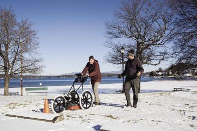
A team of professors, doctorate and post-doctorate students braved the 25-degree temperatures to conduct what is likely the first archaeological radar-based survey of the site Monday.
The team chose to conduct their survey in the offseason, when fewer vehicles would be using the space.
According to Kitchel, Weirs Beach was a popular spot for people to find artifacts like arrowheads before it was paved. Ironically, paved areas like the Weirs Beach parking lot and the drive-in theater provide an extra layer of preservation for artifacts. The lots prevent increased development and are still able to be surveyed with modern equipment to locate potential settlements and artifacts.
“The reason we know this site is special and dates back 10,000 years is that in the 1970s, an archaeologist named Charles Bolian of the University of New Hampshire conducted a number of test excavations in anticipation of the installation of some storm water drains,” Kitchel explained. “That's when they found those really old artifacts.”
The Weirs Beach artifacts and evidence consisted of primitive stone tools, charred plant seeds from fires, and even darker patches of earth which could be the result of fish cleaning. Many of the geographic features we see today are the result of massive glaciers that carved out the land across North America during the ice age.
“My area of interest is the first peoples here in New Hampshire during the Ice Age and just after and how people responded to environmental change and the end of the Ice Age,” Kitchel said.
During the Ice Age, which only ended just about 11,500 years ago, much of North America, Europe and Russia were covered by massive ice sheets and glaciers. As global temperatures rose, the ice receded, changing the earth's landscape, ecology and how humans lived.
“The end of the Pleistocene [era] here in New Hampshire is one of the more substantial periods of environmental change globally in the past 11,000 years, so understanding how those environments changed and how people coped with those changes is interesting to me, especially as we face our own period of impending climate change.”
To help understand how people lived, the team deployed a ground penetrating radar device, or GPR, to pierce the earth below and gather data. The machine looks like a three-wheeled lawn mower, and scans 50-centimeter slices in a method similar to a fish finder, where a signal is sent and bounces off buried objects. The data is interpreted in a series of horizontal lies with varying bevels and bumps that researches like Jon Alperstein, can decipher.
“We can tell if there's something buried below the surface and roughly how deep it is, too,” Alperstein said as he pushed the GPR along. Alperstein pointed out a small bulge in the lines, describing it as a possible pit site, or where ancient peoples may have stored food or waste.
“We can reference it with the magnetometry cart,” Alperstein said of objects found via GPR, and gesturing toward another device at the end of the parking lot. “If it's a big piece of metal we'll know it's not something from the late Pleistocene or early Holocene" era.
The magnetometry cart is so sensitive that metal and electronic objects need to be kept at a distance of 10 meters, and operators can't wear metal items like belt buckles when the device is in use in order to ensure accurate readings.
“If there's a glaciation here too we can recreate that former landscape, essentially creating a paleo digital terrain model of what's going on,” Alperstein explained. “That would be a really nice outcome.”
“Jon's sort of a wizard of post-processing these data, so he'll be able to perhaps even extract some 3D models from this line,” Kitchel said.
“We do all different forms of archaeological remote sensing,” explained Professor Jesse Casana, who also directs the school's Spacial Archaemetry Lab.
“We run projects all over the world, but especially during the pandemic we've been doing quite a bit more research locally here in New England,” Casana continued. “I've always been particularity enthusiastic because I'm from here originally.”
Casana grew up on the Weirs, and explained his family owned the north end of Lakeside Avenue.
“My grandfather owned the Superette general store for many years, and I in the '90s ran the bowladrome for a couple summers,” Casana said. “For me it was kind of a homecoming and it's fun to be back.”
“It's a nice confluence of events,” Kitchel said. “Jesse being from here, but also having all this incredible technology that allows to us to come to what would really be a hard site to survey otherwise.”
The team also expressed the possibility of conducting a small archaeological dig if something really special was found.
“Something we've certainly considered is a more controlled excavation to better understand what they found in the 1970s,” Kitchel said.
“We can learn a whole lot without a big excavation,” Casana said. “Doing this kind of technology combined with some very targeted, small excavations would be able to yield a whole bunch of information that today is unknown.”
Casana and Kitchel also thanked the community and the city's parks department for their cooperation with their work.
“So far, the Laconia parks have been very welcoming and supportive,” Casana said.
“And the community,” Kitchel added. “I came down and spoke to a community forum to talk about what it would mean and what we'd hope to do in the future.”
“We were pretty excited about it,” said Mathew Mansur, assistant director of recreation and facilities of the Laconia Parks Department. “I think it's awesome. The very first thing I tell my staff before the season starts, I give them a little history of the place from what I get at weirsbeach.com, and tell them that Weirs Beach means a lot to a lot of different people.”


(0) comments
Welcome to the discussion.
Log In
Keep it Clean. Please avoid obscene, vulgar, lewd, racist or sexually-oriented language.
PLEASE TURN OFF YOUR CAPS LOCK.
Don't Threaten. Threats of harming another person will not be tolerated.
Be Truthful. Don't knowingly lie about anyone or anything.
Be Nice. No racism, sexism or any sort of -ism that is degrading to another person.
Be Proactive. Use the 'Report' link on each comment to let us know of abusive posts.
Share with Us. We'd love to hear eyewitness accounts, the history behind an article.