


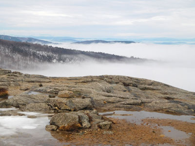
Summit of Mt. Majora
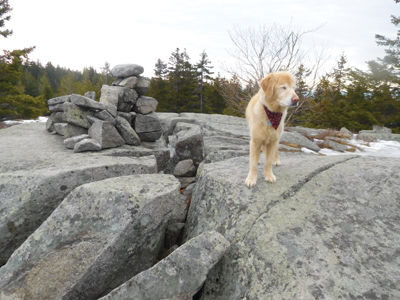
Reuben on Summit of Piper Mountain
By Gordon DuBois
Maybe you’ve heard of the Triple Crown of horse racing, winning the Kentucky Derby, Belmont Stakes and the Preakness. There’s also the Triple Crown in long distance hiking, The Appalachian, Pacific Crest and the Continental Divide Trails and the Triple Crown of baseball. In the Lakes Region we have our own triple crown, traversing the three major mountain ranges, Belknap, Squam and Ossipee. Traversing end to end of each range is not only a considerable challenge, it is also a rewarding accomplishment. Last week I set out to begin my attempt to complete the Winter Lakes Region Triple Traverse in 5 days. The total mileage for the traverse is over 40 miles, while summiting 19 mountains. I began the week with a warm-up/conditioning hike to the summit of Mt. Carrigain (4,700 ft.) via the Signal Ridge Trail, a 15 mile round trip ramble. Two days later I began the Lakes Region Triple Traverse (LRTT) by driving to the Mt. Major Parking Lot, off Rt. 11, to commence the trek across the Belknap Range.
The Belknap Range lies to the west of Lake Winnipesaukee and stretches across three towns, Alton, Gilmanton and Gilford. The highest peak in the range is Belknap Mountain (2,380 ft.). Other lesser peaks include Clem, Mack, Straightback, W. Quarry, E. Quarry, Anna, Piper, Whiteface and Major. The Belknap Range Trail (13 miles) traverses the entire range from Mt. Rowe in the north to Mt. Major in the south. The traverse features stellar views of the Ossippee and Sandwich Mountains. The trail also passes along the shores of Round Pond with several campsites on the south end of the pond. The Belknap Range Trail (BRT) is blazed with distinctive trails markers to guide the adventurous hiker along the path.
It was a warm, gloomy day when I started, cruising up the blue blazed trail to the summit of Mt. Major, with Reuben leading the way. However, my cruising ceased when I was met by ice flows covering the trail. I put on my trail crampons and safely made it to peak. The low lying clouds hung below me covering the lake. Above the cloud cover, the Sandwich and Ossipee mountains rose up, out of the clouds. It looked like the ocean had flooded the area and only a few mountainous islands stood above the sea. After this brief pause I continued on the BRT to Straightback- South Peak.
From Straightback Mountain Reuben and I trekked to Mt. Anna and onto Mt. Mack and Clem, following the BRT blazes and snowshoe tracks from previous hikers. I was surprised to find them, as this section of the trail is rarely used in winter. I dropped down off Mt. Clem to Round Pond, where I had lunch. My journey then took me to the Boulder Trail. I was reluctant to climb the Boulder Trail, as it climbs steeply, through an enormous rock slide. With the warming temperatures ice chunks the size of a minivan were breaking free off the rock cliffs and careening down the mountainside. It was a quick, “no brainer” decision to forego climbing the Boulder Trail, and we headed to Piper Mountain. Reuben and I then took the long climb to Belknap Mountain, eventually landing at the summit of Gunstock Mountain, close to the summit chair lift. Reuben seemed tired and ready to sleep, but with a number of kids willing to play with him he came to life, frolicking in the snow, showing off and prancing around the skiers who were taking his picture. One little boy asked me, “Where are Reuben’s skis?” We finished the Belknap Traverse on Mt. Rowe, where Karen met me for the final push to the Gunstock parking lot.
Two days later Reuben and I were heading to the Ossipee Range to meet Tom and Karen for the circuitous traverse, along the western ridge. The Ossipee Mountain Range lies across from the Belknap Range on the east side of Lake Winnipesaukee. If you were to view the Ossipee Range from above it would look like a giant circle, 40 miles around. The mountain range is what’s left of an extinct volcano, the subsurface remains of the magma chamber. The center of the mountain range is the bottom of the caldera, the volcanic cone that collapsed. The traverse of the western side of the Range falls almost entirely within the Castle in the Clouds Conservation Area (Lakes Region Conservation Trust). It runs from Mt. Roberts (2982 ft.) to Mt. Black Snout (2803 ft.). The High Ridge Trail, which is aptly named, traverses the upper reaches of the conservation area and follows the crest of the mountain range.
Tom, Karen, Reuben and I climbed to the summit of Mt. Roberts (2582 ft.), where we were met by outstanding views of the Sandwich Range. This is my favorite trail in the Ossipee Range, because of the outstanding views and the diversity of the forest along the path. After a brief pause we then glided along the High Ridge Trail, eventually making it to Mt. Shaw, following a series of carriage roads and snowmobile trails that slice through the area. At the summit of Mt. Shaw (2,990 ft.) we were met by darkening clouds, wind and light snow. It reminded us we were still in the throes of winter. We ambled along carriage roads to Black Snout and Turtleback Mountains, finishing the traverse by bushwhacking the western slope of Turtleback and Bald Knob Mountains, eventually ending our day at Shannon Pond. We covered five summits and fifteen miles in about ten hours. One more traverse to go, the Squam Range.
The Squam Mountain Range, running east to west is primarily a ridge of peaks rising above the northern end of Squam Lake. It’s the remains of ancient volcanic action millions of years ago as the Pangea Super Continent was breaking away from what is now North America. The major peaks are Doublehead, Squam, Percival, Morgan, Webster, Livermore and Cotton. The entire ridgeline has outstanding views and also features rock scrambles, ledges, summit ponds and waterfalls.
Two days after completing the Ossipee traverse Reuben and I met Ken, Karen, Dick and Dave in Holderness. It was another warm, spring-like day, filled with sun and some clouds. The “Weather Gods” were with me again. We dropped cars at various trailheads along the range on Rt. 113. Reuben and I were the only ones in the party planning to hike the entire Squam Range. We all hopped in one car and drove to Mead Base Camp in Sandwich. We began our trek on the Sandwich Notch Road, hiking to the trailhead of the Crawford-Ridgepole Trail. The trail was a steep and challenging climb to the ridgeline. Ken set a blistering pace, knowing it was a long slog with difficult rock climbs and surprisingly deep snow. The Squam Range held several surprises: “glacial ice” on the rock climbs, significant snow cover and infrequent blazes. After changing from crampons to snowshoes and back again we summited Doublehead Mountain. We continued to push on knowing that the going was slow and we were at risk of being benighted. We continued to push forward hiking over Mt. Squam, Mt. Percival, Mt. Morgan and Mt. Webster. We only stopped occasionally to take in the spectacular views of Squam Lake, the mountains to the southwest and to grab an occasional snack.
As dark was approaching Ken, Karen and Dave took a side path off the ridge to their waiting car. Dick had left us earlier at the summit of Mt Percival to begin the trek back to his car. I was now left on my own to finish the traverse. Reuben and I continued our journey climbing Mt. Livermore. As we reached the summit the sun was sinking in the west, giving off an orange glow that reflected off the snow. The mountainside was dimly lit by the residual light of the setting sun, but soon darkness consumed the forest and I had to don my headlamp to complete the traverse, ending on Rt. 113, where Ken and Karen were waiting for Reuben and me.
Reuben and I finished The Lakes Region Triple Traverse in 3 days, hiking 44 mountainous miles and climbing 19 summits. Our tired muscles and achy bones cried for a hot shower (not Reuben) and a warm bed (for Reuben it’s the sofa). If anyone has completed the LRTT please let me know, or if you are planning to take the challenge I would like to hear from you at forestpd@metrocast.net
Gordon has hiked extensively in Northern New England and the Adirondacks of New York State. In 2011 he completed the Appalachian Trail (2,285 miles). He has also hiked the Long Trail in VT, The International AT in Quebec, Canada, Cohos Trail in northern NH and the John Muir Trail in CA. Gordon has summited the New Hampshire 200 Hundred Highest peaks, the Northeast 111 highest peaks and the New England Hundred Highest in winter. He spends much of his time hiking locally and in the White Mountains with his dog Reuben and especially enjoys hiking in the Lakes Region due to the proximity to his home in New Hampton.
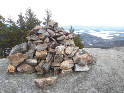
Summit of Mt. Percival


(0) comments
Welcome to the discussion.
Log In
Keep it Clean. Please avoid obscene, vulgar, lewd, racist or sexually-oriented language.
PLEASE TURN OFF YOUR CAPS LOCK.
Don't Threaten. Threats of harming another person will not be tolerated.
Be Truthful. Don't knowingly lie about anyone or anything.
Be Nice. No racism, sexism or any sort of -ism that is degrading to another person.
Be Proactive. Use the 'Report' link on each comment to let us know of abusive posts.
Share with Us. We'd love to hear eyewitness accounts, the history behind an article.