


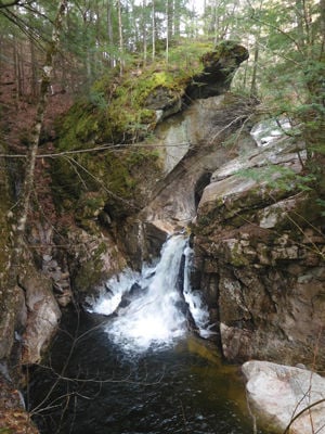
Welton Falls from the Lower Manning Trail
By Gordon Dubois
I reached the river crossing on the Lower Manning Trail and found myself stuck. I could go no further. Winter temperatures had been set in motion and ice was forming along the banks of the Fowler River. No way could I cross to the other side, where the trail continues, without risking life and limb. One slip on a rock and I would find myself tumbling downstream; worse yet my head could possibly be smashed to smithereens. My destination hike to Welton Falls was now in jeopardy of being aborted.
However, I was not to be denied by a river crossing strewn with ice covered rocks and boulders. I was determined to find safe passage. I searched for a crossing, striding ceaselessly up and down the side of the river. All that I could see was ice- covered rocks and boiling water. I was getting discouraged and ready to turn back, when I suddenly spotted a series of boulders with no ice. They rose up out of the stream, like sentinels guarding the river. This was the place for safe passage. I felt like Froddo Baggins (Lord of the Rings) making his way through the Old Forest. These boulders could be used as stepping stones and with any luck they will get me across the river. I lowered myself down the bank and onto the first gigantic rock. From here I stepped gingerly, one boulder at a time, watching carefully for any ice covering the foothold. I looked down once, noticed the swirling eddies below and raised my eyes quickly, focusing on the dry boulders ahead. At last I was across the river, where I rested on terra firma. I could now continue my journey to Welton falls.
This is the shoulder season, when fall is fading and winter is close at hand. The morning began under cloudy skies and cold temperatures. A chilling breeze sent icy fingers through my outer jacket. I was on this hike as part of a writing assignment for a conference I was attending, Writing From the Mountain, sponsored by the Appalachian Mountain Club. We were spending the weekend at the AMC Cardigan Mountain Lodge. The lodge is nestled near the foot of Cardigan Mountain, at the end of peaceful Shem Valley Rd. on a 1,200 acre reservation in Alexandria, NH. The valley was carved out by the glaciers 12,000 years ago. The summit of Cardigan is composed of three main peaks-South Peak, Cardigan Peak and Firescrew. In 1855 a massive forest fire raged over the mountain denuding the entire summit of vegetation. The fire was so intense it threw flames hundreds of feet into the sky. Firescrew was named for the spiral of fire and smoke that rose from the peak. The summits have never recovered from the fire, but the valley has recuperated from the devastating inferno. Nature has a way of healing its wounds and marvelously restoring the forest to its former self. Cardigan is a place where you can find a challenging climb, as well as a leisurely woodland walk. The mountain preserve is also a favorite destination for backcountry skiers and has a plethora of ski trails for a wide range of abilities.
The Lower Manning Trial begins adjacent to the Cardigan Lodge. The trail wanders through several camp sites and then enters the Welton Falls State Forest. Here I encountered a forest of gigantic hemlocks and beech. Brown leaves scattered along the trail swirled around my feet as I bustled along. I soon found myself hiking along the Fowler River. The trail overhung the river in several places, where the Fowler had undercut tree roots and soil. With each storm and spring runoff the banks of the river are pushed wider, trees become imperiled, eventually falling into the water.
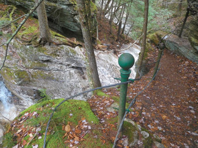
After making my risky crossing of the Fowler I continued my trek to Welton Falls and encountered “clear sailing”. No more rushing streams to cross. Within a matter of minutes (.2 miles) I noticed a cable fence in disrepair, guarding the trail, keeping onlookers from tumbling into the boiling waters below. Looking over the precipice of the roaring cascade, I was struck by the stark beauty of this waterfall, walls of granite rising up from the foaming water. It was easy to see where the glaciers, as they melted, sent tons of water, rock and debris down the river carving out the chasm below. Blocks of ice clung to the sidewalls of the gorge. I found a resting spot to contemplate the stunning beauty around me and I tried my feeble best to capture the moment:
Water rushing by underfoot,
Signs of high water lay about: trees, boulders, sand, silt.
Sheets of ice cover the river and the granite cliffs,
Winter closing in.
Ancient broken trees cling to the ledge,
Tree trunks riddled with holes from woodpeckers
Searching for a tasty delight.
Roots undercut by the rushing water.
Ancient rotting branches
Reaching with outstretched arms for sunlight,
Trying to stay alive.
Beech tree pocked with warts,
Moss crawling up the trunk;
Shelf fungus taking hold of the rotting bark.
I notice a small hemlock seedling
Emerging from the dying tree.
Green needles show off brilliant color,
As they rise like a phoenix.
A sign of new life,
Replacing the old and dying member of the forest.
The circle of life, never ending.
After this brief respite I decided to continue my hike and not return the way I came. Besides, I didn’t want to risk crossing the river again. I made my way along the bank of the river, encountering one more river crossing, this time much easier. At 1.3 miles I reached the junction with the Old Dicey Rd. Once on the Old Dicey Road I found myself walking leisurely along, taking in the warming rays of the sun. Stone walls lined the road indicating that at one time this was a main road to somewhere, but where? There are no indications of a settlement in the area. Eventually after a mile walk I left the Old Dicey Road and began my circuitous route back to the Cardigan Lodge on the Back 80 Loop.
The Back 80 Loop Trail gradually climbed a ridge reaching the junction with the Back 80 Trail. At the junction I found a good-size cellar hole, once the homestead of a pioneering family. I pondered the life of these early settlers who carved out an existence in the wilderness. I admired their fortitude and grit, their ability to build a substantial home in this desolate wilderness of the early 1800’s. Now I was returning to the comfortable accommodations of a 21st century lodge. The hike from the cellar hole back to the lodge was a quick mile, mostly downhill. I made it back just in time for the start of our next session with no river crossing to impede my hike.
This hike can be done as an out and back to Welton Falls (2 miles) or continue as I did. I would not recommend this trail at this time of the year. Wait until later in the winter when the Fowler River is frozen or better yet, during the summer when the water crossing is easy and you can jump in the river for a quick dip.
There are a number of options you can choose as there are a vast array of over 50 miles of trails within the AMC Cardigan Reservation and the Cardigan Mountain State Forest. The AMC Cardigan Lodge can be reached by taking Rt. 3A out of Bristol, then turning right onto West Shore Rd. Continue to Alexandria and then onto Cardigan Mt Rd. Stay on this road, it will turn into Shem Valley Rd. and you’ll arrive at the lodge and trail heads. If you would like more information about the lodge and accommodations call 603 744 8011.
Happy hiking and stay safe.
Gordon can be contacted for comments or questions at forestpd@metrocast.net
Top of the Welton Falls


(0) comments
Welcome to the discussion.
Log In
Keep it Clean. Please avoid obscene, vulgar, lewd, racist or sexually-oriented language.
PLEASE TURN OFF YOUR CAPS LOCK.
Don't Threaten. Threats of harming another person will not be tolerated.
Be Truthful. Don't knowingly lie about anyone or anything.
Be Nice. No racism, sexism or any sort of -ism that is degrading to another person.
Be Proactive. Use the 'Report' link on each comment to let us know of abusive posts.
Share with Us. We'd love to hear eyewitness accounts, the history behind an article.