


By Gordon DuBois
Early last week Sandy Price contacted a few of her trekking buddies and suggested a hike on the Three Ponds - Kineo loop trail, starting and finishing at the trail head off Rt. 118 on Forest Road 211. Now you may wonder why Sandy would want to hike these obscure and almost abandoned trails in the Rumney region. Well, Sandy is working on a list called "Red Lining". Red Lining means hiking all the more than 1,000 miles of trails marked in red that are in the AMC White Mountain Guide. Sounds like a crazy list but I know people who have completed it, or are working on this list. I joined her because I have hiked in this area and wanted to return and bushwhack to the summit of Mount Kineo. Fran and Dick, two experienced hikers, jumped on board and we set out on a beautiful warm spring day.
The Three Ponds area and Mount Kineo lie north of Rumney and west of Thornton. The trails in this section of the White Mountains offer delightful opportunities for day hikes to Stimson, Rattlesnake and Carr Mountains. Both the Carr and Stimson summits were once the sites of fire towers and the remains of these towers are still evident today. The trail system in this area also provides a pleasant day hike starting from Stimson Lake Road to the shelter on the shores of Three Ponds. The hike we chose to embark on is less well traveled and very obscure in some sections. In the AMC Trail Guide, it is not recommended for inexperienced hikers. A map and compass are essential and a GPS can be helpful.
We began our hike at the gated National Forest Road, number 211. This USFS road merges with the Hubbard Brook trail which leads to Hubbard Brook Road and into the Hubbard Brook Experimental Forest. This USDA Forest Service research station was established in 1955 as a major center for forest hydrologic research in New England. In 1988, it was designated as a Long-Term Ecological Research site by the National Science Foundation. The first documentation in North America of the long term effects of acid rain on vegetation and water quality were done here. The area is still active in doing cooperative research in the fields of soil physics and forest hydrology. The research being done in this experimental forest will also help in the understanding of climate change and its effects on forest ecology.
We began our hike on the Three Ponds Trail, which took us over Whitcher Hill, named after one of the first settlers in on the town of Warren. As we progressed along the trail it became difficult to follow, as the treadway became obscured with hobble-bush. Hobble-bush is very appropriate name for this shrub as it grows throughout the openings on the forest floor, tripping and ensnaring hikers in a web of branches. Even though Hobble-bush is bothersome to hikers, it throws out beautiful white and pink flowers in the spring. We could only follow the trail because of surveyor's tape that someone had placed on trees along the supposed route. Without the tape we would have had a difficult time finding the trail. Many wildflowers were in bloom throughout the forest floor, giving notice that spring had arrived and summer was fast approaching. All along the trail were hepatica, purple and pink trillium, spring beauties, wild oats, bedstraw, Indian poke and goldthread. Trout lilies were everywhere, shooting up their delicate flowers, signaling the beginning the trout fishing season. The oak, maple, birch and beech trees were throwing out their new leaves to bathe in the warm, spring sunlight. It was the perfect idyllic spring hike in New Hampshire, with no black flies (yet).
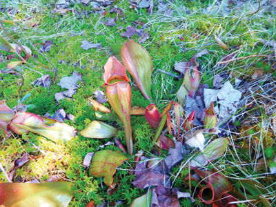
After crossing Whitcher Hill, we descended into the depression that holds the three ponds. We passed by Foxglove Pond (no Foxgloves in bloom) and in a swampy area we found a number of pitcher plants waiting for their spring meal. This plant grows in wetlands and is unique in that it doesn't look like a normal leafy plant. It's carnivorous, just like many of us, and devours insects by attracting them with a sweet nectar and then digesting them with a fluid that is similar to the juices in our stomachs, amazing! After stopping to admire the view we continued on our journey to Three Ponds, crossing a beaver dam and onto the Donkey Hill Cutoff. This was the first of many beaver ponds we encountered. From this trail we then swung onto the Mount Kineo Trail, which started as a snowmobile trail and reverted back to a wilderness pathway. We climbed steeply up the side of Mt. Kineo (3,313 feet) until we reached the height of land, where we began a bushwhack to the summit. This was about a two mile round trip diversion from the trail, but Kineo is on the NH 200 highest summits lists, so why not grab it.
Returning to the Mt. Kineo Trail we began the long descent to Hubbard Brook Road, Hubbard Brook Trail and eventually back to where we started the hike.
However, this adventure was far from over. Our hike off the Kineo Ridge took us into a beautiful valley and as we made our way along the trail we began to encounter a series of beaver communities. The beaver flowage and dams were extensive, flooding the trail in many sections. At one point we noticed a trail marker on a tree sitting in the middle of a beaver pond, and we had to make several detours. The trail from here on out was not marked and the footpath was non- existent. I believe the only ones using this trail are moose, deer, fox and coyote. We continued to be enthralled with the wildflowers blooming around us and the many beaver ponds that were active or dried up. Upon leaving the valley, we finally arrived at the junction with Hubbard Brook Road, which turns into Hubbard Brook Trail. As we neared the end of our hike, we encountered a barred owl, calling to its mate. We looked up and there he was overhead, sitting on a branch of a tree. We watched him for several minutes as he flew from tree to tree, staying close by. As we continued our hike he flew along overhead, perching on tree limbs and watching us, seeming to say, "I'm keeping an eye on you invaders!" After taking many pictures of this guardian of the forest, we left him and his mate, listening to their familiar call, "Who cooks for you, who cooks for you."
As we ended our day after hiking, a total of 16 miles in 12 hours and nearing nightfall, we looked forward to a cold drink. On our way down Route 118, we had a perfect ending to the day. We spotted a very large black bear roaming along the highway. We pulled over to watch him ramble along, stopping occasionally to watch us. It was the perfect ending to a day spent in the wonders of nature and being a part of the beauty that is all around us when we are on the trail.
As a footnote to this hike, I am reminded that anyone hiking or biking in the New Hampshire woods should obtain a Hike Safe Card. This card can be purchased on line from NH Fish and Game. The purchase of the card supports NH Fish and Game Search and Rescue efforts and you will be exempt from liability in repaying for rescue efforts if caused by reckless or negligent behavior. Remember to always plan properly and hike safe, happy trails.
Pitcher Plant


(0) comments
Welcome to the discussion.
Log In
Keep it Clean. Please avoid obscene, vulgar, lewd, racist or sexually-oriented language.
PLEASE TURN OFF YOUR CAPS LOCK.
Don't Threaten. Threats of harming another person will not be tolerated.
Be Truthful. Don't knowingly lie about anyone or anything.
Be Nice. No racism, sexism or any sort of -ism that is degrading to another person.
Be Proactive. Use the 'Report' link on each comment to let us know of abusive posts.
Share with Us. We'd love to hear eyewitness accounts, the history behind an article.