


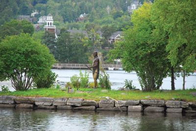
A statue of Chief Cocorua stands on an island in Meredith’s Clough Park. Lake Winnipesaukee, 504 feet above sea level, once only had an elevation of 250 feet. (Laconia Daily Sun photo/Adam Drapcho)
LACONIA — The Weirs Channel, located right next to Weirs Beach, is a historic location for a number of reasons. But one little know fact about the channel is that is actually the third location at which water flowed out of the 44,586-acre Lake Winnipesaukee on its way to the Atlantic Oean.
The other outlets, according to Adair Mulligan's 1995 history of Gilford entitled “The Gunstock Parish,” were in Alton as the last ice age came to a close around 12,000 years ago and later through what is now Lily Pond in Gilford.
Lake Winnipesaukee at that time was only 250 feet above sea level and as the giant ice sheet melted, the water flowed through Alton Bay, which was twice as large as present, down into the Cocheco Valley and the sea, which extended all the way north to Rochester. As the ice melted, the land, which had been covered by ice hundreds of feet thick, bounced back and the meltwater then began to flow through lower channels at Lily Pond and still later through Paugus Bay.
“It is tempting to speculate how differently Gilford might have developed in such proximity to the seacoast region,” Mulligan wrote.
According to Edgar H. Wilcomb in his publication "Winnipesaukee Lake Country Gleanings," 1923:
“The rough, broken region southwest of the Weirs, at the head of Lake Paugus, back to the Meredith hills, shows evidence of enormous volumes of water and ice having passed down this way, checked and turned in its southerly course by Racoon Mountain, forming a part of the westerly section of the great natural dam at Lakeport, indicating that the level of the water was high enough to flow north of Blacksnout Mountain, northwest of the Weirs, as well as between this mountain and the Gilford Mountains. Old Blacksnout must have withstood a terrific battering of water and ice cakes during the tremendous flow, before and after its tough old head was uncovered.
“When the great dam broke at Lakeport, an immense flow of water must have started in that direction. Probably the bulk of the water first flowed through the valley comprising the present Intervale and Lily Pond section, east of the White Oaks hill, but it is obvious that there was another channel west of the White Oaks, at what is now the Weirs, and that the waters scoured out this channel so rapidly that it eventually became lower than the Intervale channel, until it constituted the only outlet of the lake.”
“At this period the present site of Laconia and all the territory embraced in the basin bounded by the great natural dam at Lakeport, the hills east of Laconia, the Sanbornton hills and the elevated section west of Meredith Center was doubtless submerged by another lake of considerable size, somewhat lower than the others, held back by another big natural dam across the present valley between Belmont and Sanbornton, a considerable portion of which was swept away by the floods until the present valley and channel of the Winnipesaukee river was formed, leaving the small lake south of Lakeport."
The Endicott Rock, located next to the Weirs Channel, where Lake Winnipesaukee empties into Paugus Bay, may be the oldest public monument in New England according to the New Hampshire Division of Parks and Recreation.
The name of John Endicott, Governor of Massachusetts Bay, and the initials of Edward Johnson and Simon Willard, commissioners of the Massachusetts Bay Colony, and of John Sherman and Jonathan Ince, surveyors, were inscribed on the rock on August 1, 1652.
The rock marked the assumed headwaters of the Merrimack River. Under the original Bay Charter of 1629, the northern boundary of the colony was fixed as a line three miles north of the Merrimack.
The rock was entirely forgotten for 181 years after the inscriptions were engraved upon it and it wasn't rediscovered until 1833, when the Weirs channel was dredged.
Efforts to preserve the rock took nearly another 60 years and it wasn't until 1892 that the state of New Hampshire completed preservation measures, including a memorial structure of granite enclosing it, which was dedicated in the fall of that year as Endicott Rock State Park.
In 1901, Dr. Alonzo Greene, owner of the New Hotel Weirs, donated a zinc allow statue which would become known as “Captain Jack” which was mounted atop the memorial and would remain for many years until struck by lightning in 1978. It was repaired and remounted in 1983 but vandalism forced its removal and it is now located in the Laconia Public Library. In 2004 the Weirs Action Committee commissioned sculptor Robert Morton of Ashland, a Plymouth State University professor, to create a new statue which would be an authentic recreation of what native Indians who had lived on Lake Winnipesaukee looked and dressed like and the statue was dedicated the following year.
Weirs Beach itself gets its name from the fishing devices used by the native Indians, who used baskets which were attached to the rocks and possibly poles set in the Weirs Channel to catch the Shad which migrated through the channel,
At that time the channel was apparently about 150 feet wide and the lake level was two to four feet below its current level, which is measured at full lake as 504.32 feet above sea level
Geologists point out that the water level of this lake has remained about the same as today. Studies of the hillsides, streams, meltwater channels; intervales, and varied deposits preclude the possibility of any glacial dams or deep waters such as Lake Hitchcock that once filled the present Connecticut River valley. The conclusion is that the Winnipesaukee River of today is very nearly the same drainage channel that the lake has always had.
In 1811 a charter was granted for a canal from Alton Bay to the sea by way of Merrymeeting, Cocheco, and Piscataqua rivers. Though the Little Pequakit Canal Company came into being in 1819, no work was done on a proposed project that was intended to eventually extend from the Atlantic Ocean through Winnipesaukee to Squam Lake, and the Connecticut River, and on to Lake Champlain and the St. Lawrence.
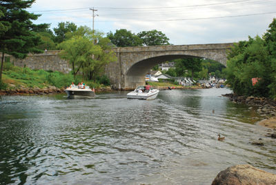
Though Lake Winnipesaukee now drains through the Weirs Channel, that wasn’t always the case. (Laconia Daily Sun photo/Adam Drapcho)


(0) comments
Welcome to the discussion.
Log In
Keep it Clean. Please avoid obscene, vulgar, lewd, racist or sexually-oriented language.
PLEASE TURN OFF YOUR CAPS LOCK.
Don't Threaten. Threats of harming another person will not be tolerated.
Be Truthful. Don't knowingly lie about anyone or anything.
Be Nice. No racism, sexism or any sort of -ism that is degrading to another person.
Be Proactive. Use the 'Report' link on each comment to let us know of abusive posts.
Share with Us. We'd love to hear eyewitness accounts, the history behind an article.