


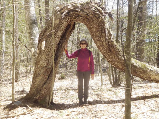
Reuben and I rock-hopped across several streams as we climbed to the summit of Fogg Hill. This was the beginning of the end of my quest to earn the Lakes Region Conservation Trust’s Explorer Patch for hiking 20 trails on 18 trust properties.
After Fogg Hill, I planned to complete the challenge that day by hiking at Fort Point Woods and Trask Swamp Preserve, Sewall Woods and Avis P. Smart Woods conservation areas. When Reuben and I reached the summit of Fogg Hill, overlooking the Snake River and Lake Waukewan, rain began to pelt down and we had to make a sudden retreat back to the truck. We had planned to complete the quest that day, but the rain delayed our finish and we had to wait another day.
I have also explored other properties conserved by Lakes Region Conservation Trust that are not on the Explorer Patch Program, such as Dinsmore Mountain Preserve, the Ainsworth Preserve and the Bear Camp River Pond and Preserve. The Lakes Region Conservation Trust has more than 150 conserved and preservation properties in the Lakes Region, totaling more than 27,000 acres. Eighteen of those properties are trailed and are included in the Explorer-Patch Program, which is designed to encourage people to visit some of the most amazing conservation areas in the state.
Fogg Hill Conservation Area
Fogg Hill is named for one of the early settlers and entrepreneurs in the Winona section of the town of New Hampton, Levi Fogg, born in 1787. After moving from Hampton to New Hampton, he bought several hundred acres of land in the Winona area that included the hummock to the east of Winona Lake and named it for himself. He built a large inn and tavern on the stage line of the Old Province Road. Stage coaches stopped at the Inn (now located on the corner of Straits Road and Winona Road) coming over Oak Hill on their way to Plymouth and the North Country.
Some believe the Province Road ran over the shoulder of Fogg Hill to avoid the steep recesses of Winona Lake, known in earlier times as Long Pond. Others contend that the colonial road climbed over Beech Hill and on into Ashland. The Province Road was first conceived in 1763 under Governor John Wentworth, founder of Wolfeboro and nephew to the better-known Governor Benning Wentworth. The Province Road was one of the first long-distance “highways” in New England. It was built to divert crops from being shipped down the Connecticut River from Haverhill to Massachusetts and instead brought by wagon along the Province Road to the tidewater port of Durham. The road north of Laconia was built sometime after 1770.
Fogg Hill and its 235 conserved acres are part of a larger unfragmented woodland and wetland habitat of more than 900 acres in the Waukewan and Winona Lake Watershed. The area is critical for preserving the water quality of those two lakes, the source of water for the town of Meredith. The property is also important habitat for wildlife and contains a number of endangered and threatened plant species.
Bear Pond, a kettle hole bog, is located just off the main trail. A kettle hole is a depression or hole formed in an outwash during the last ice age, as the glacier was retreating northward. Bear Pond is one of only a few kettle bogs in the area.
Trail access to the Fogg Hill Conservation Area is off Piper Hill Road in Center Harbor.
Sewall Woods Conservation Area
Sewall Woods is located in Wolfeboro, near the center of town and is a tremendous resource for that community, offering residents a vast and intricate trail system for hiking, skiing, trail running, snowshoeing, bike riding, birding or just enjoying a walk in the woods. A few days after my rainy hike to the summit of Fogg Hill, Karen and I, without Reuben, headed to Sewall Woods for a leisurely stroll. We found the preserve by driving south on Route 109, and turning onto Sewall Road just as we entered into the downtown of Wolfeboro.
Upon parking the car at the trailhead, we noticed the ski lodge, used in winter for cross-country ski enthusiasts. Shortly after beginning our stroll, we were met by a plethora of trails. We were amazed at the options for our ramble through the woods that were once pastures and open fields owned by local farmers. The trails were easy to follow with the LRCT map, marked clearly and mostly level, no hills to climb. Near the trailhead, we were struck by the number of invasive plants trying to take over the forest: oriental bittersweet, Japanese barberry, and multiflora rose. It’s apparent that the Lakes Region Conservation Trust and the Wolfeboro community are working hard to control these invasives and preserve the forest’s natural beauty.
Fort Point Woods and Trask Swamp Preserve
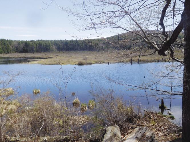
In my opinion, Fort Point Woods and Trask Swamp Preserve in Alton is one of the premier conservation properties in the Lakes Region and one not to be missed. After spending a couple hours roaming through Sewall Woods, Karen and I drove south on Route 28 and then to 28A, driving seven miles, turning onto Chestnut Cove Road for five miles, and then onto Fort Point Road, where we found the kiosk for Trask Swamp Preserve. The 183 acres of conserved woodland and wetland have been protected since their purchase in 1995 by the Lakes Region Conservation Trust for research, wildlife protection, education and recreation. It’s a botanically unique and diverse wetland and upland forest that is home to diverse flora and wildlife, including a heron rookery.
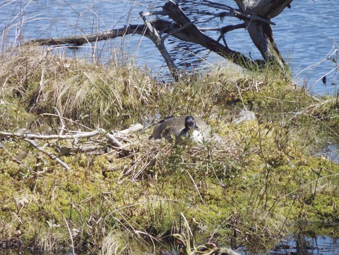
Karen and I began our hike along a well-marked trail that led us into a spectacular woodland and wetland. After hiking for a quarter mile, we found the trail that would take us to Trask Swamp. When we reached the shoreline of the pond and wetlands, formed as a result of extensive beaver activity, we took a break for lunch, sitting on a log and admiring the view. As we sat munching on our sandwiches, we became enthralled by the bird and aquatic life that jumped into view. We gazed at a pair of mallard ducks swimming about, the male flashing his wings to gain the attention of his mate. Then along came a pair of black ducks looking for a nesting site near the water’s edge. Black ducks look similar to mallards, as the two species hybridize frequently. Swallows were swishing over the water, along with phoebes, catching insects for lunch. In the distance, we took notice of a heron rookery, with a pair of herons nestled in two of the nests. Painted turtles began to emerge from the water, sunning themselves on logs and tree stumps. Fossil remains show that this turtle existed more than 15 million years. We also noticed beaver lodges on the far side of the pond, but no beaver were seen, as they prefer to be out and about in the evening.
After this extended interlude, we continued to follow the trail, hoping to find spring flowers popping out of the ground. With the extended cold and wet spring we’ve been experiencing, it seemed that the flora we would normally see at this time hadn’t sprung from the ground yet. We did happen upon a trailing arbutus that seemed to be struggling to open its beautiful, delicate flowers.
Nearing the end of our hike, we accidently found two stone columns with the date inscribed uniquely with small stones: “1932”. The columns obviously marked the entrance to the estate of a local resident. We also found a large stone foundation and well-built stone walls. I learned later that there is a small cemetery of the French Family near the trailhead, burials from 1861 to 1888.
Besides the natural beauty of this property, there is a story that needs to be told. If anyone knows more about the French Family or the stone pillars and foundation, I would like to know.
Alice P. Smart Woods
The Alice P. Smarts Woods Conservation Area was the last stop on our Lakes Region Conservation Trust rockin’ around the lake excursion. After leaving Fort Point Woods and Trask Swamp Preserve and still pondering the history of the property, we began our journey home, driving to Gilford on Route 11, turning onto Watson Road, and finding the kiosk and tiny parking space for the small conserved property. The 32-acre forest was once productive farm land and contains a magnificent stand of sugar maples that were first tapped in the mid-1800s.
Karen and I finished our day of hiking by following the Loop Trail that provided us with a leisurely tramp through woods of about a half-mile. That short walk made for a fine ending to the day and the end of my Explorer Patch quest. I am also the first finisher, and who will be the second finisher?
For more information about the Explorer Patch Program, visit the Lakes Region Conservation Trust’s website at lrtc.org. You can visit their office on Dane Hill Road in Center Harbor and pick up trails maps and the official list of all trails and properties on the Explorer Patch Program.
For questions or comments, contact Gordon at forestpd@metrocast.net.


(0) comments
Welcome to the discussion.
Log In
Keep it Clean. Please avoid obscene, vulgar, lewd, racist or sexually-oriented language.
PLEASE TURN OFF YOUR CAPS LOCK.
Don't Threaten. Threats of harming another person will not be tolerated.
Be Truthful. Don't knowingly lie about anyone or anything.
Be Nice. No racism, sexism or any sort of -ism that is degrading to another person.
Be Proactive. Use the 'Report' link on each comment to let us know of abusive posts.
Share with Us. We'd love to hear eyewitness accounts, the history behind an article.