


By Ben Barry
A deep-diving underwater glider is set to begin an epic 73,000km five-year journey circumnavigating the entire globe to collect data to improve weather forecasting.
The pioneering world-first tech will launch from the edge of the continental shelf, south of Martha's Vineyard, Massachusetts, on Oct. 10.
The glider will dive to depths of 1,000 meters and surface every eight to 12 hours and use satellites - sharing vital data on ocean temperature, salinity, currents, and ocean health.

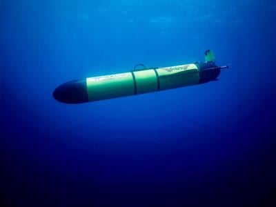
Redwing test launch. (Teledyne Marine via SWNS)
This data will help refine weather models and improve hurricane intensity forecasting. The data will also help to inform ocean policy and conservation efforts.
Redwing’s 73,000-km (over 45,000 miles) journey will see it ride the Gulf Stream south of Martha’s Vineyard toward Europe, before sweeping south to stop at Gran Canaria off the coast of North West Africa.
Its next leg will take it to Cape Town in South Africa, before crossing the Indian Ocean to stop at Perth in Western Australia, then on to Wellington, New Zealand.


The pioneering five-year mission will be launched from the edge of the continental shelf, south of Martha's Vineyard, Massachusetts. (Teledyne Marine via SWNS)
It will then navigate the Antarctic Circumpolar Current - the most powerful current on Earth - taking it on its longest leg to the Falkland Islands.
From here, there will be possible stops in Brazil and the Caribbean before heading back to Cape Cod in the U.S.
Brian Maguire, COO at Teledyne Marine, said: “This is a truly historic mission.
“It will pave the way for a future where a global fleet of autonomous underwater gliders will be able to continuously sample our oceans.

The glider will dive to depths of 1,000 meters and surface every eight to 12 hours and use satellites - sharing vital data on ocean temperature, salinity, currents, and ocean health. (Teledyne Marine via SWNS)
"These gliders will deliver early warnings of extreme weather and will track the impact of shifting ocean currents so that we can refine long-term weather projections in a way that scientists have dreamed of for decades.
“It will also prove that long-range, next-generation, low-energy autonomous underwater vehicles (AUVs) are capable of carrying more complex, heavier, and increasingly energy-hungry sensors on missions that we could only have imagined previously.”
This mission was launched in collaboration with Teledyne Marine and Rutgers University-New Brunswick.


(0) comments
Welcome to the discussion.
Log In
Keep it Clean. Please avoid obscene, vulgar, lewd, racist or sexually-oriented language.
PLEASE TURN OFF YOUR CAPS LOCK.
Don't Threaten. Threats of harming another person will not be tolerated.
Be Truthful. Don't knowingly lie about anyone or anything.
Be Nice. No racism, sexism or any sort of -ism that is degrading to another person.
Be Proactive. Use the 'Report' link on each comment to let us know of abusive posts.
Share with Us. We'd love to hear eyewitness accounts, the history behind an article.