


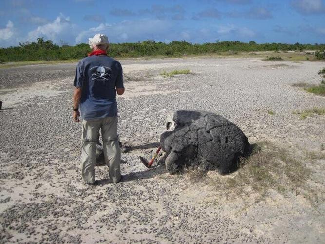

An earthquake between 1381 and 1391 triggered a tsunami in the northeastern Caribbean sea that stranded large coral boulders hundreds of meters inland on Anegada, the northernmost of the British Virgin Islands. A new University of Washington-led study dates the event based on analysis of the coral. Co-author Robert Halley is pictured beside a specimen. (Brian Atwater via SWNS)
By Stephen Beech
Coral skeletons left by a tsunami over 630 years ago are a warning for the Caribbean region, according to new research.
An earthquake exceeding magnitude 8.0 rocked the north eastern Caribbean sometime between 1381 and 1391, sending a tsunami toward the island of Anegada, say scientists.
Flooding scattered debris across the island, in what is now the British Virgin Islands (BVI), depositing coral boulders hundreds of yards inland.
The corals died, but their skeletons remain.
More than six centuries later, scientists say that the skeletons hold vital clues about the history of tsunamis.
Computer models showed the flooding likely resulted from a tsunami generated during a large earthquake in the nearby Puerto Rico Trench.

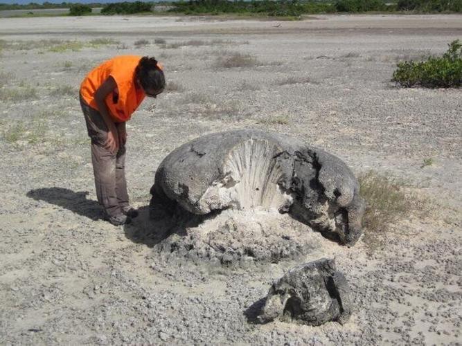
Zamara Fuentes, a postdoctoral student at the University of Puerto Rico Mayagüez, examines the coral skeleton. (United States Geological Survey via SWNS)
The new study, published in the journal Geophysical Research Letters, narrows the tsunami time frame to the last decades of the 14th Century.
The researchers say their findings will support ongoing efforts to prepare for future Caribbean tsunamis.
Corresponding author Professor Brian Atwater said: “If you’re designing a school or a hospital near the coast, you want to know whether there’s a chance that a very big earthquake could occur, and you want to design that building to withstand it.”
Atwater, of the University of Washington and a geologist with the United States Geological Survey, added: "Anegada is the northernmost of the British Virgin Islands, sitting just south of the Puerto Rico Trench, where the Caribbean and North American plates converge.
"Most of the islands are protected by a broad, shallow continental shelf.
"Waves lose energy as they roll across the expanse, decreasing the chances of a tsunami hitting Caribbean shores.
"Anegada is different - the seafloor slopes steeply toward the deep trench, making the island more hazard prone."


Written records from the region go back five centuries, but none provide evidence for a tsunami from the Puerto Rico Trench.
Geology allowed the researchers to evaluate tsunami history on a longer timescale.
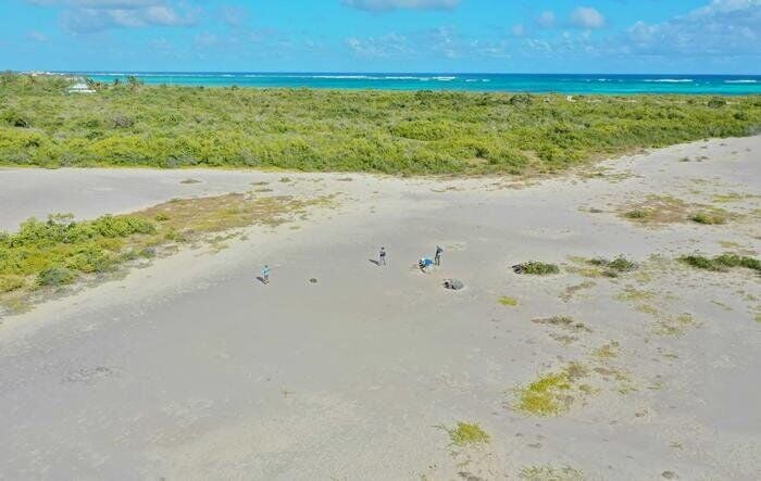
The tiny figures in this drone photo are standing near one of the stranded coral boulders on Anegada, showing how far inland the tsunami, dated in this study between 1381 and 1391, carried it. (Michaela Spiske via SWNS)
Scientists began surveying the region after a massive earthquake and tsunami struck the Indian Ocean in 2004, killing more than 250,000 people.
The disaster surprised everyone, including researchers, prompting U.S. officials to take a closer look at coastal hazards on the Atlantic seaboard.
Uri ten Brink, one of the project leads and a research geophysicist at Woods Hole Coastal and Marine Science Center, asked Atwater to check for signs of similar activity on Anegada.
Atwater spent years in Indonesia after the tsunami.
The evidence uncovered on Anegada drew various research teams to the island and produced a series of discoveries.
In the most recent study, led by Professor Hali Kilbourne, researchers presented a time frame for the medieval tsunami based on how old the coral was when it died.

(Photo by Dane Amacher via Pexels)
They calculated age by measuring two radioactive elements, uranium and thorium, that decay at known rates.
The measurements were made on samples from the inside of the coral skeletons, due to weathering and potential contamination.
The research team then added the number of annual growth bands between the dated sample and the exterior of the coral to estimate when the tsunami occurred.
Kilbourne, of the University of Maryland Center for Environmental Science, said: “Corals have annual density bands, much like tree rings.
She added: “We were able to count how many years passed between the top density bands and the sections we used for dating.”
Kilbourne plans to continue studying the samples to better understand climate change over longer timescales.


(0) comments
Welcome to the discussion.
Log In
Keep it Clean. Please avoid obscene, vulgar, lewd, racist or sexually-oriented language.
PLEASE TURN OFF YOUR CAPS LOCK.
Don't Threaten. Threats of harming another person will not be tolerated.
Be Truthful. Don't knowingly lie about anyone or anything.
Be Nice. No racism, sexism or any sort of -ism that is degrading to another person.
Be Proactive. Use the 'Report' link on each comment to let us know of abusive posts.
Share with Us. We'd love to hear eyewitness accounts, the history behind an article.